
A reusable VR toolkit for immersive archaeological storytelling.
About the Experience
The Kormantin Archaeology Toolkit is a modular VR system designed to support immersive archaeological storytelling and pedagogy.
Developed by Professor Michael J. Jarvis (Department of History) in close collaboration with Studio X, this VR digital heritage experience showcases both the historical site and the archaeological excavation process. The toolkit was piloted using data from excavations at a 1640 English castle in Abandze, Ghana, known historically as Kormantin.
University of Rochester and Syracuse University scholars have been conducting archival research and archaeological investigations to uncover the site's history since 2017 to learn that the present-day fort completely replaced the original Castle Cormantine. Professor Jarvis created models through 3D scanning of the heritage site.
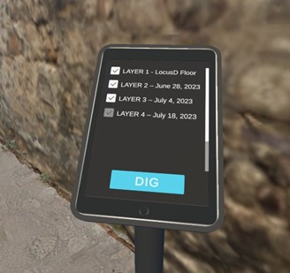
This virtual experience allows visitors to explore the site, discover scholarly findings, and learn how archaeologists reconstruct historical locations. Users can travel back to summer 2023 and use a virtual tablet to "dig" through layers, revealing Kormantin's early history. However, the project's scope extends beyond creating a site-specific tour—we've developed a modular toolkit that can enhance other virtual archaeological experiences.
Key Features Design & Development
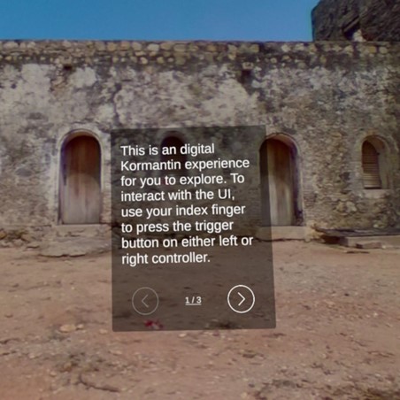
- An onboarding tutorial
The onboarding tutorial introduces visitors to the historical context, which can also serve as a tutorial for VR interactions, making the experience accessible to users with varying levels of VR familiarity.
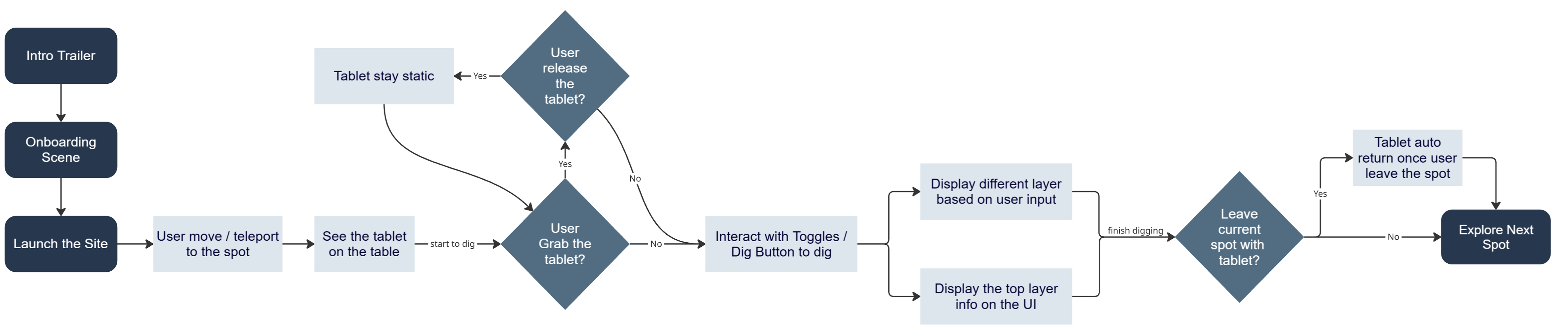
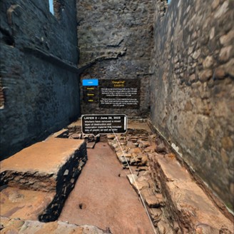
- An interactive, tablet-based virtual reality excavation system that visualizes archaeological layering
Aimed at providing an immersive learning experience and presenting archaeological knowledge in an interactive way, this system allows users to grab and interact with a virtual tablet. Users can utilize UI buttons on the tablet to toggle each excavation layer on and off, experiencing the archaeological process first-hand. Additionally, an information panel corresponding to each layer provides detailed context for users to read and learn about specific discoveries and techniques.
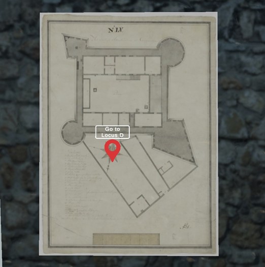
- Map navigation system
While designing for VR, we prioritized creating a friendly, accessible, and comfortable user experience. This map navigation system enables an easy, quick way of navigation while minimizing motion sickness. With this system, users can gain a better understanding of the overall site layout and teleport directly to specific excavation areas where archaeologists conducted their work for in-depth exploration.
- A modular Unity toolkit adaptable for future VR heritage experiences
- Photogrammetry-based site reconstruction from fieldwork data
Why Build a Toolkit for Virtual Excavation?
This project was initiated to develop a flexible toolkit that enables archaeologists, educators, and cultural heritage professionals to share excavation sites and interpretive narratives through immersive media. While grounded in Professor Jarvis’s research in Ghana, the ultimate goal is to support scalable, reusable workflows that reduce technical barriers and expand public access to archaeological knowledge.
Timeline
February 2025
- Ideation and experience design
March 2025
- Prototyping and developing core tablet excavation system
- Prototyping and developing of onboarding interface
- Test and refinement
April 2025
- Design and implementation of map navigation system
- Project iteration and debugging
Summer 2025
- User testing
- Toolkit optimization and documentation
